

You asked and we built it! The incredibly popular 3D rendering feature in ZoomProspector can now be used to add multiple buildings to any site. With this change, it's easier than ever for prospective investors to literally picture their investments on the available sites in your community.
 Launched last year, the 3D Rendering tool was made available in every property listing across all our clients' ZoomProspector web tools. More than 800 3D renderings have been created by web visitors since the feature was launched. The DIY feature means anyone can do it, without needing to rely on expensive and time-consuming consultants.
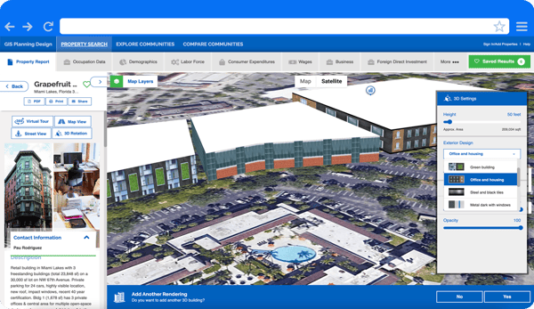
We invite you to try it out for yourself on any ZoomProspector application. Select the 3D Rendering option from the web tools list on the bottom and draw your own building to spec in the map. The tool allows you to modify the height, choose from one of the beautiful preset designs or select a color from the palette, along with other modifiable options such as opacity, light intensity and how the patterns repeat in the design. When you are done, the feature will now ask you if you want to add another building. Website visitors can add as many as they like. The 3D Rendering tool prompts users to save the renderings they like, which can then easily be shared with the Share button.
Saved renderings are only visible to the website visitor who created them, to anyone who opens the custom URL link they share and to the economic developers managing their community's ZoomProspector admin. They can be added to RFI responses and shared on social media, in email campaigns, newsletters, and more.
Since we launched this tool at the beginning of 2022, clients have told us that one of the most valuable aspects of the new feature is the ability for them to see in their Admins all of the 3D renderings that have been created. This gives their economic development organization a good idea of how prospective investors see the property. This is incredibly useful actionable intelligence when working with site selectors or businesses making location decisions.
GIS Planning is proud to lead off our 25th year as the original creators of GIS data mapping tools for economic development and site selection, consistently the leading provider of these tools in the US, Canada and around the world. No other vendor offers an easy-to-create 3D rendering feature in every property listing - one more example of our commitment to continued innovation.
Would you like to learn more about how GIS Planning's award-winning suite of GIS data tools can help drive investment to your community? Schedule your demo today!