

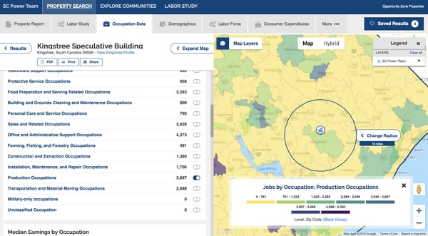
We're pleased to announce an exciting new partnership with Emsi to add occupation data by ZIP code for interested U.S. clients. This data can be used to identify where jobs are growing and concentrated below the county level. ZIP code data helps researchers figure out the pockets of their cities—whether that's a 30-mile radius around a proposed site or a set of ZIP codes—that have specific types of skills and needs.
We’ve made it possible to integrate in our site selection tools to help businesses chose locations in areas with employees in sectors that suit their needs. The new Emsi data can be integrated into the Labor Force reports on the GIS Planning ZoomProspector GIS data tools, as well as the Demographics and Mapping Intelligence Components. Check it out on the new SC Power Team ZoomProspector tool below.
Why does this new data matter for economic developers?
Both urban and rural organizations will appreciate being able to identify where jobs are growing and concentrated below the county level. ZIP code data helps researchers figure out the pockets of their cities — whether that's a 30-mile radius around a proposed site or a set of ZIP codes — that have specific types of skills and needs.
Emsi is the industry leader in labor market data for economic and workforce development. Emsi builds ZIP-level employment data using data sets from Bureau of Labor Statistics, Census Bureau, and other federal and state sources. EMSI starts with robust county-level industry numbers from the BLS, and combines them with Census Bureau’s ZIP code estimates and BLS occupation data to create comprehensive ZIP-level employment data.
Learn how to use this data to benefit your economic development by checking out this video recording of our recent 30-minute webinar.
What will you learn at the webinar?
Josh Wright, from EMSI, joined Alissa Sklar our VP of Marketing for a review of the available data and go through the steps to implement it in your online data tools.
- Examine the strategic value of dynamic workforce data
- Review the different forms of data now available to GIS Planning clients, including occupation detail by zip code, jobs, wages and industry data
We're always looking for ways to improve our product offering and are happy to bring Emsi to our growing list of data partners. This new partnership with EMSI means you can add EMSI data to your online GIS data tool at reduced cost. Contact us to learn more.
