

If there is one thing we've all learned from the COVID-19 pandemic, it's how absolutely critical it is to have top quality digital tools to connect with people, whether it's for business, for teaching and learning, for entertainment, for planning or for fun.
Always at the forefront of innovation, we at GIS Planning saw a need for an easy-to-use virtual tour software that would let people create their own self-guided tours of their communities. For business. Or tourism. Or education. Or film location promotion. Or city planning. Or any of a zillion reasons you might have to showcase specific features of your region.
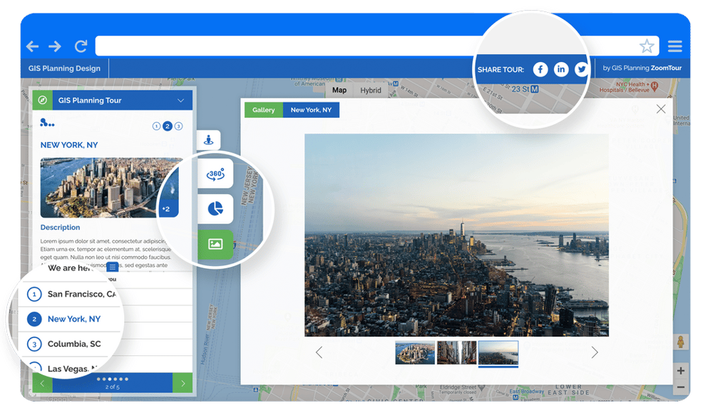
That's the thinking behind ZoomTour, our newest product. ZoomTour is a cloud-based software that helps you create any number of interactive, multimedia, virtual tours for your community - you'll quickly see that there's nothing else like it on the market. Come see how South Carolina's North Eastern Strategic Alliance (NESA) has created their first ever interactive online tour with this innovative new product.
How can I use it?
Use ZoomTour to build engaging, online tours on the themes of your choice and share them on your website, on social media, in proposals, e-newsletters, email campaigns and more. ZoomTour walks your users through self-guided tours with maps, images, video, audio, and data. Build in links to websites and social media accounts for the organizations and companies you visit along the way. It's easy to use with our ZoomTour dashboard - no training or experience required.
If you can map it, we can help you tour it.
Let your imagination be their guide. There are countless possible applications for ZoomTour:
- Economic development - Create tours to showcase featured properties, business parks, their community's value proposition or to attract workforce
- Create a tour of the businesses and amenities for each of your target industries
- Take us on a walk through your downtown district or different neighborhoods
- Film locations - Guide your viewer through different locations to consider for film and video shoots, highlighting their amenities
- Tourism - set up tours of your parks & recreation facilities, top restaurants, arts & cultural institutions. You can have a whole ZoomTour dedicated to places of historical interest or annual line-up of festivals around the area
- Convention Bureau - Design a ZoomTour to showcase the feature of your convention center and its location
- Business development - Showcase the anchor companies, tech startups, or featured businesses in your region
- FDI - Build a tour of the most significant foreign direct investment projects in the area
See ZoomTour in action here on the NESA website.
You don't need to use other GIS Planning tools to enjoy ZoomTour, but if you do have them on your website, ZoomTour offers compelling new ways to share your data from those applications.

