

As economic developers everywhere grapple with the new realities of the COVID-19 outbreak, many have found themselves fixated on an entirely new set of data about how the coronavirus is playing out across their region. Given this concern, GIS Planning has added a new layer of free relevant data on all U.S. ZoomProspector applications.
As of today, our clients' website users will be able to track daily updated county-level data in their communities from the Map Layers section on their interactive GIS data tools. This allows them to layer the data alongside other variables and available properties in their region, which can yield analysis of specific interest to economic development professionals, as well as community stakeholders. It further increases the utility of ZoomProspector as an open-access data portal for their website visitors. With the new data layer, users can track the following data:
- Total cases
- Total deaths
- New cases
- Total cases per 10K population
- Chmura's JobsEQ Vulnerability Index (click to read more about this)
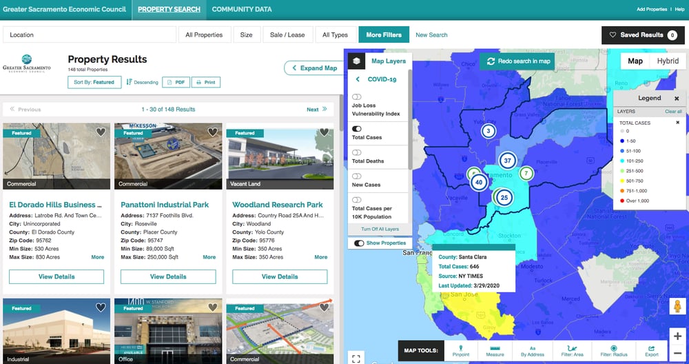
The data comes from the New York Times, which is tracking the information for every county in the country. It is updated daily.
Clients in other countries have asked if we can add the same data mapping for them. It all comes down to finding the right data sources. If we can find reliable, granular data, we can look into mapping them. For inquiries about this, you can email us at support@gisplanning.com.
For more information about ZoomProspector, please click on the button below.

