

A significant advantage to licensing the data in our industry-leading online GIS data tools directly from our data providers is the ability to provide you with more interactive data for your website users to analyze and share. This makes it easier to recognitive the economic development initiatives and policies your organization has developed as priorities for your region.
GIS Planning is proud to include the top data providers in the industry so we can make the data interactive for entrepreneurs and site selectors so they can get the key information they need. Furthermore, we've built our GIS tools specifically to make this data shareable with a single click. While some old school GIS systems force end users to rely solely on PDFs to share demographics and business data, our clients and their users recognize that today's investors insist upon dynamic sharing, with links that bring the user back to your website for more research and analysis.
Here are the top data sources you'll find in GIS Planning web tools:
Labor Force - EMSI and Chmura's JobsEQ
We team up with both EMSI and Chmura's JobsEQ to provide the best labor force data available in the market.
Not only does this support the conventional heat mapping users enjoy but you can also do a drive time or radius analysis around any property, any polygon of your choice or do pinpoint analysis (with or without a property).
Check out the JobsEQ data here on Georgia EMC's ZoomProspector. You can see an example of the EMSI data integration below on the Beacon Council website or here on the State of Indiana ZoomProspector tool.
![]()
Data Axle
Because GIS Planning licenses data directly from this provider, our clients and their website users can do significantly more analysis with our GIS web tools. Data Axle (formerly InfoGroup/InfoUSA) is the leader in business data, supplying companies such as ESRI and Google. Our access to this raw data is the game-changer - we are one of the very few solutions to enable users to map businesses by type, revenue, # of employees etc for any area of your choice.
One of the most popular uses of this data is the ability to create and customize industry clusters to promote or research key sectors. We all know that a picture is worth 1000 words; by allowing users to see the business displayed visually on an interactive map, they can instantly understand, analyze and process the way these businesses are dispersed across your geography and around available properties. Infinitely more powerful than an old-fashioned PDF. And since our Data Axle license allows us to provide real-time data, you can count on daily updated information in GIS Planning tools.
You can see the InfoGroup USA business data live here on the Pinellas County Economic Development site. Here are some other examples of business reports used to analyze different variables:
- Businesses with more than 200 employees in Pinellas County (FL)
- Mapping Advanced Manufacturing around a property in Ohio
Census Data
Many companies rely on census data to provide demographic data. We've built U.S. Census data into our American tools and Statistics Canada data into our Canadian tools. The former are further enhanced by information from the American Community Survey to provide the most current demographic data (Canadian projections are provided by Environics Analytics).
Google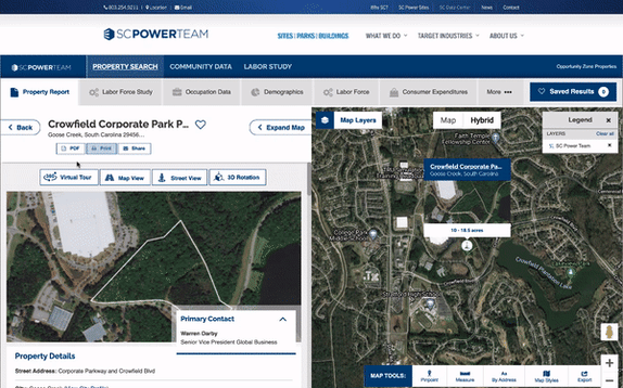
Economic developers everywhere have come to realize they need virtual tours and street views in the COVID era where travel may be restricted. Fortunately, Google has already done that work for us; GIS Planning can integrate that beautiful, powerful, and easy-to-use imagery and 3D images right into your current system. A review of most real estate systems and sites like Zillow, Trulia, AirBNB, Loopnet, CREXI.com, Realtor.com, CoStar (Showcase) will make it clear that Google is the common denominator. You can see an example of how we've integrated Google Earth in the image on the right.
Want to add your own additional digital tours such as 3D architectural renderings, drone video, immersive video or interactive walk-throughs of interiors? No problem! You can add any additional tours with our Custom Tour button on all properties. See an example of a custom tour on this North Carolina's Southeast (NCSE) property report - click on the Custom Tour button to see what they've added.
FDI data
The addition of the FDI data to ZoomProspector offers a critical extra level of research potential unmatched by any other online GIS site selection data tool in the industry. The data, which comes from fDi Markets, tracks seven years of greenfield investment into any region, which can be viewed by country, amount of investment, jobs, number of projects and sector. You can view this data live on the Florida Power & Light's Office of Economic Development Explore Florida tool.
Talent data
Labor and talent data can be very time-consuming and challenging to source, which is why our Talent Pool reports get such heavy use, both internally by economic development teams and externally, by visitors to their websites. See it live here on the Focus Centra PA web tool. Talent Pool reports include the following features:
- Top college degree production for a location
- Top universities' production by number of graduates
- Analysis by radius or drive time around a potential business location
- Drill down by different institutions, degrees and fields of study
- Export graphs in different formats
- Link, email or social sharing options for this report
Your OWN Local GIS Data
We realize your city or region might already have other local GIS data of your own; we can integrate this into your ZoomProspector system. Our in-house client services team will work with any file format to help you get this information online.
Want to know more about how the GIS Planning suite of online data tools can work for your region? Contact us today.