

Economic development data is critical to the practice of investment attraction, business retention and corporate site selection. GIS Planning is proud to offer a top quality range of data providers with the information investors need to make location decisions. But having the right data isn't enough - it's also how you use it. Here are five effective key questions you need to ask about your online GIS data tool:
 1- Is your data interactive? Static data may have been acceptable back in 2005 but it certainly doesn't fly today. Your website users expect to be able to roll up their sleeves and analyze the data with a variety of tools, including heat maps, dynamic reporting, radius, pinpoint, drive time analysis, and more. Users want to be able to map out a specific industry cluster or list companies attributed to a NAICS code they want to analyze. If site selectors on your website are being asked to rely on static PDFs, the hard truth is you are not meeting their needs. You are likely losing leads without even knowing it.
2- Can your data be visualized? Your GIS tool is a powerful way to show - not just tell - your region's value proposition. The human brain can instantly comprehend data presented in visual formats that would take far longer to understand as a spreadsheet. It's easier to process this visual data, make connections and decisions, and then recall all of this later on. Examples of visualized data in an online GIS tool are thematic heat maps and map layers, as well as in supporting charts, graphs, and infographics. Check out this data snapshot from the Detroit Region as an example. You must be able to map properties and demographics, but also businesses, industry sectors, consumer spending, and labor force data.
3- Can you use your data in creative ways to bring readers back to your website? After all, that's the goal of marketing and promotion. If you just send them a PDF you are not bringing them back to your website to learn more about what you offer. Unique share links are built into all our dynamic reports, so it's easy to bring them back to your web tool to view the specific heat map, industry analysis or custom drawn area you've created. Check out the GIF below or follow this link to see what I mean. 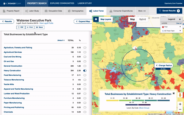
4- Are data reports branded with your EDO name and logo? If downloaded reports prominently feature the name and logo of a 3rd party vendor and not your organization, you risk getting lost in the shuffle. Whose marketing should be taking precedence when a business is considering investment into your region? To see an example, check out this Consumer Spending report for Indianapolis-Carmel-Anderson, IN.
5- Are all features mobile friendly? If your website visitors don't have access to the same maps, reports, interactive tools, data and virtual tours on their mobile devices, they will quickly get frustrated and click away. Whenever a vendor claims to be mobile responsive, we strongly urge you test drive their online GIS tool to see whether they can truly deliver the whole package from a smartphone or tablet. You may find you can't access all maps, reports or features. That risks losing about one-third of your website visitors right off the top. Want to see how ZoomProspector performs on a mobile device? Click on this link to the Beacon Council web tool from your smartphone or tablet.
Learn more about GIS Planning's industry-leading suite of online data tools for site selection. Book a demo today.