

Safe to say, 2020 was a year for the books. No question, we'll all be glad to say good bye to this one. But in the midst of this crazy, challenging year of COVID and wildfires and chaos of all kinds, we also saw many instances of real innovation and advancement from leaders in all fields. As economic developers everywhere work hard (often from home offices, cleared off dining room tables, or hastily set up corners of their living rooms) to support their local businesses, collaborate with local officials, and continue to attract new investment to keep their regions smoothly, the GIS Planning team stepped up to offer new ways to help them do their jobs as effectively as possible.
We are proud to offer this summary of the top five innovations and advancements from this past year, all of which stand poised to assist your organization move into recovery mode for 2021. These are the reasons GIS Planning has always remained the industry leaders in online data tools for economic development - they are the reason we can confidently announce #WeAreWhatsNew:
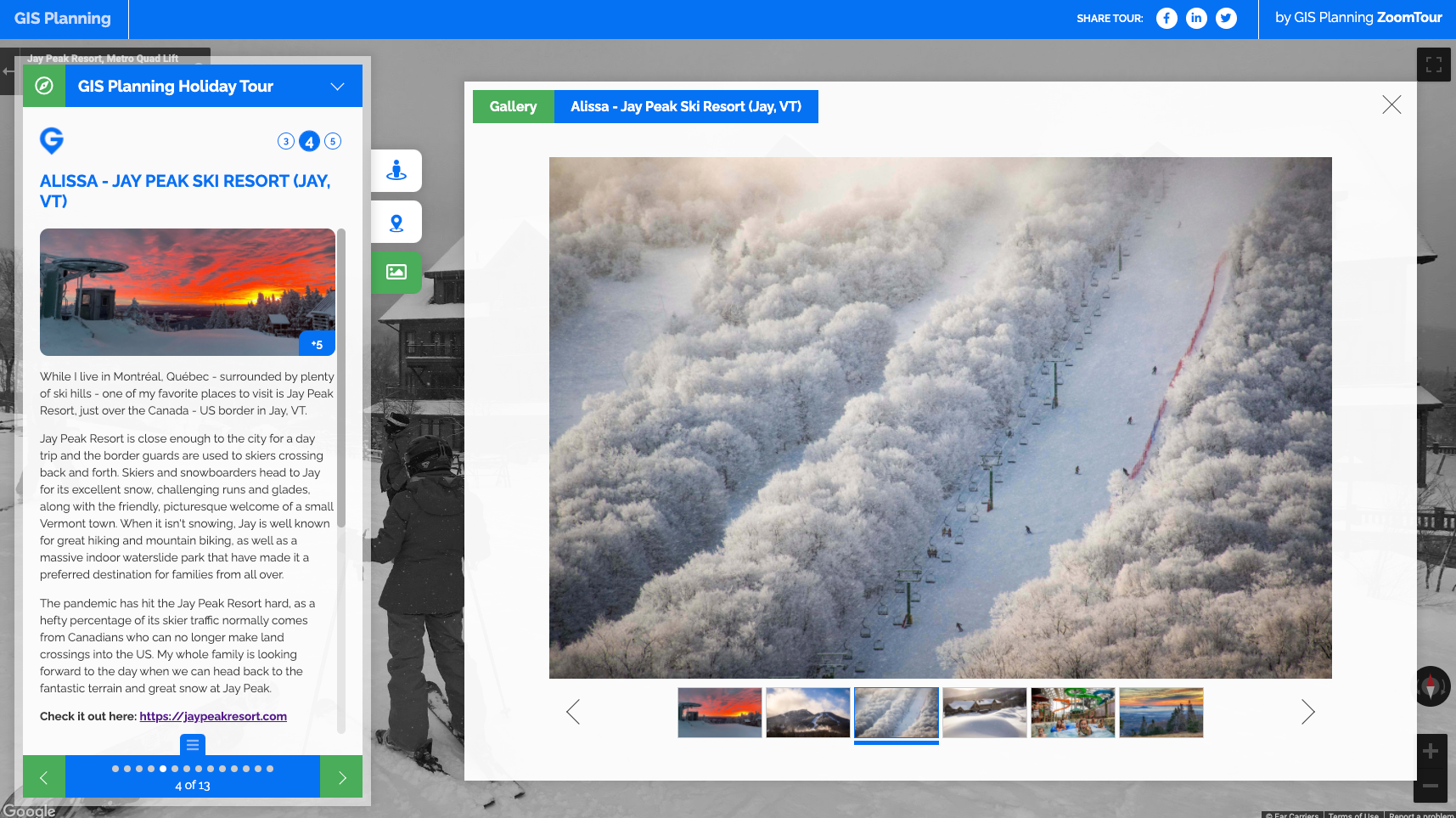
1) ZoomTour: We ended the year with perhaps our most exciting innovation of all - cloud-based software that helps you build your own beautiful tours. Create any number of interactive, multimedia, virtual tours for your community - you'll quickly see that there's nothing else like it on the market. Come see how South Carolina's North Eastern Strategic Alliance (NESA) has created their first ever interactive online tour or check out our company's holiday tour of the team's favorite businesses by clicking on the image below. Learn more here.
 2) ZoomBusiness: When the pandemic hit back in March, we heard from our clients that their biggest concern was for the businesses in their communities. Our team sprang into action, launching an interactive, map-based directory of local businesses in mid-April, so that consumers and area residents couldactively support those companies and organizations that are the source of jobs and the lifeblood of their local economies. We made the tool free for existing ZoomProspector clients and highly affordable for everyone else. We've since had more than 100 communities across the US and Canada actively implement ZoomBusiness, and the tool is positioned to be just as relevant post-pandemic, as a way to list and support entrepreneurship and business. Learn more here.
3) Community Comparison Tool: In October, we introduced a new Community Comparison tool built directly into ZoomProspector. Choose one region from within your geography and compare it to as many others as you like from across the country. Full reports compare a robust list of variables for demographics, labor force and consumer expenditures. See the data expressed in charts and in easy to read tables. Got a long list of communities to compare? No problem! The user-friendly scrolling table keeps the client community anchored in place so you can view it alongside each one of the others. Learn more here.
4) Virtual Tours & Custom Tours in ZoomProspector: Travel restrictions make it tricky to connect potential investors and site selectors with the properties they want to view in your area. And while the world has learned to adapt to using digital tools more and more, the ability to offer virtual tours will remain critical even after those restrictions loosen. That's why we have built 360° virtual tours directly into ZoomProspector, automatically added for every property in your system. Clients who want to add additional kinds of virtual tours, such as 3D architectural renderings, drone video, immersive interiors, digital walk throughs and more, can easily do so with the Custom Tours button. Learn more here.
5) Drag & drop Proposal Generator: Built right into your ZoomProspector location analysis tool, the drag and drop Proposal Generator make it easier than ever for your team to collaborate virtually to build effective, polished responses to RFIs. Just as important, while you can certainly download it as a PDF for printing, you can also share this live document online, so that the properties offered are easily updated on the fly. Your proposal will always reflect the most current inventory of properties on offer. Video can be added directly to pages or property reports and pages of marketing collateral can be easily saved for use in future proposals. Learn more here.
BONUS! 6) Smart bubbles: Back in February, we debuted a new way to display larger numbers of properties on maps in ZoomProspector.The GIS Planning algorithm looks for map markers that are near each other within a certain radius and then represents all those separate dots as a new cluster, indicated by the blue or green bubble (for sites and building, respectively). We then added a number inside the bubble to represent all the nearby points. The icons are smart because as you click on them, the results refresh on the fly. This dramatically improves the user experience. Learn more here.
To learn more about any of these new products and features, click below to connect with our team.